Viluppuram
For Viluppuram Tours, Sightseeing & Hotel Booking CLICK HERE
Viluppuram
History And Geography
Viluppuram District lies between 11 38 25N and 12 20 44 S 78 15 00 W and 79 42 55 E with an area of 7222.03 Hec. It was carved out from the South Arcot District on 30.09.1993 and was rehristened as Viluppuram District. The residual part of the erstwhile South Arcot district was named as Cuddalore District. It is surrounded on East and South by Cuddalore District. The West by Salem and Dharmapuri District and on the North by Thiruvannamalai and Kanchipuram District.
Agriculture
The chief food crops of Viluppuram district are paddy, Cholam, Ragi, Cumbu, Redgram. Blackgram, Horsegram and Varage. The chief cash crops are Sugarcane, Groundnut, Cotton, Casurina and Coconut.
Industry
Viluppuram district is developing in the industrial sector. The Sugar industry is the major industry in the district. There are 4 sugar factories at Mundiyampakkam, Periasevalai, Kacharapalliyam, Mungailthuraipattu. In the area of small schale industries there are 67 Rice mills, 17 Sago factories 5 Rice bran oil extracting units and 8 Cotton Ginning Mills. Besides this mineral water, ceramics, automobile workshop are also running in the district. Major minerals produced, in the district includes Black granite, Blue metals, River sand etc. There is no Industrial estate in the district and when compared to the population the industrial establishments are quite inadequate to meet out the job requirement of the educated youth.
Events and Festivals
Koovagam Festival Transgenders, popularly known as ‘aravanis’, are in the midst of celebrating the 18-day-long Koovagam festival, an annual event that attracts their kind from abroad, including Singapore and Malaysia, and from across the country, including Delhi, Maharashtra, Himachal Pradesh, Tamil Nadu and Karnataka. Their focal point during the fete is Koovagam temple, where the presiding deity is Aravan, to whom the ‘aravanis’ will get figuratively wedded on Tuesday night. During the Mahabharata war, Arjuna, a past master in archery, killed Aravan with the prowess of his bow and arrow. Therefore, it literally meant that those ‘aravanis’ wedded to Aravan were rendered widows overnight.
Tourism
Viluppuram is the district headquarters of the Viluppuram District, which was bifurcated from the erstwhile composite Sourt Arcot District from 30th September, 1993. It is the Second largest District in the State which lies in the middle of the Tiruchirapalli to Chennai National Highways No. 45. It is well connected by the rail road and it is major junction. From here one can go to any corner of the Tamil Nadu as well as to other part of India. This district is having variety of tourist spots which are more than 100 years old. The district has temples, masques and churches which are very old and famous. We are welcoming you to visit our district tourist places.
How to reach Viluppuram
By Road: Viluppuram is well connected with important National Highways NH45A(South-East upto Nagappattinam). NH45 (North – South) and NH68 (Leading to West via Ulundurpet) also NH66 (North-West via Tindivanm) Bus: A main bus stand (New Bus Stand) is situated in the heart of the city near Master Plan Complex having all important offices like Collectorate, Court, etc., and well connected with all Mofussal Routes & Town Bus Stand (Old Bus Stand) – Local Routes.. By Rail: Viluppuram Railway junction is one of main Junction in the Tamil Nadu. So it plays an important role in transportation in south India. By Air: The nearest International airports is Chennai Airport (147Km) and Puducherry airport (43km).
Tourist Information Tourist Officer Tourist Office First Floor, THADCO Building, Opp. Government Hospital, Villupuram District LandLine : 04146-224300 Mobile : 7397715677 Email : to.villupuram@tn.gov.inPlaces of Interest
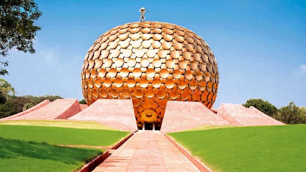
Auroville
Auroville is a universal township in the making for a population of up to 50,000 people from around the world. The concept of Auroville – an ideal township devoted to an experiment in human unity – came to the Mother as early as the 1930s.In the mid 1960s the concept was developed and put before the Govt. of India, who gave their backing and took it to the General Assembly of UNESCO. In 1966 UNESCO passed a unanimous resolution commending it as a project of importance to the future of humanity, thereby giving their full encouragement.
The purpose of Auroville is to realise human unity – in diversity. Today Auroville is recognised as the first and only internationally endorsed ongoing experiment in human unity and transformation of consciousness, also concerned with – and practically researching into – sustainable living and the future cultural, environmental, social and spiritual needs of mankind. On 28th February 1968 some 5,000 people assembled near the banyan tree at the centre of the future township for an inauguration ceremony attended by representatives of 124 nations, including all the States of India. The representatives brought with them some soil from their homeland, to be mixed in a white marble- clad, lotus-shaped urn, now sited at the focal point of the Amphitheatre. At the same time the Mother gave Auroville its 4-point Charter. They come from some 49 nations, from all age groups (from infancy to over eighty, averaging around 30), from all social classes, backgrounds and cultures, representing humanity as a whole. The population of the township is constantly growing, but currently stands at around 2,500 people, of whom approx one-third are Indian.Melmalaiyanur
Angala Parameswari Temple is located at Melmalayanur which is 32 km from Gingee in Viluppuram District. The deity of the temple is the Sembadavars. There is an ancient snake pit in the inner sanctum. Goddess Mother Parvathi the wife of Lord Shiva took birth on her as hive. The purpose of the birth is to clear Lord Shiva from certain sin and give blessings to all people in kaliyugam. The birth took place her before the start of kaliyugam. The birth place is melmalaiyanoor, where the temple is situated. The specialty in this temple is Mother in Angala Amman faces north while blessing devotees.
A festival celebrated here during February-March is famous for Simimasana Kollai. During the festival many pilgrims cook large quantities of various kinds of grain and set it out in the burning ground. This offering to the goddess is believed to grant wishes. Lots of devotees throng to the temple during Ammavasai (New Moon day). Lakhs of devotees visit here every new moon and full moon days since it is supposed to be auspicious during these days.Gingee Fort
Gingee is known as GINGEE in Tamil. The small town of GINGEE was once a capital city, With its province extending from Nellore in the north to the Coleroon (Kollidam) in the south. According to local legend, GINGEE Amman, was one of the seven virgins who were the guardian deities of the Village. Legend has it that at around 1200 A. D. , GINGEE was fortified by Ananda Kone, chief of the local shepherd community. In 1240 A. D. Krishna Kone . His successor is said to have fortified the northern hill which later came to be known as krishnagiri.The kone dynasty gave way to the kurumbars, who established their headquarters at Sendamangalam,which later came under the powerful Chola empire. Recorded history goes back to the 16th century, when Gingee (GINGEE) became the seat of the Nayaka rulers, who were under the lordship of the expanding Vijayanagar empire. Krishnadevaraya appointed Krishnappa Nayaka, and he was considered the founder of the Nayaka line of Gingee.
Most of the structures, fortification walls and temples were built during this period. The fortifications and defenses were further strengthened under chatrapati shivaji, the great Maratha ruler, was captured Gingee in 1677 A. D. Gingee came under the hegemony of the Moghul emperor Aurangazeb in 1691 A. D., and sarup singh was appointed as the chief of Gingee by the emperor, under the control of the Nawab of Arcot. Sarup Singhs son. Raja De singh, revolted against the Nawab of Arcot, and was defeated and killed in the war that followed. Though Gingee became a part of the Nawabs territory in 1714 A. D . the young and courageous De Singh became a legend and his heroic deeds were sung in the form of popular ballads. Thus Gingee too became quite well known. In 1750 A. D., Gingee came under the French rule and remained so till it was surrendered to the British in 1761 GINGEE today, with its ruined forts, temples and granaries, presents a different picture from the glorious splendor of its bygone days. But the remains of that valorous past, speak volumes about the numerous invasions, warfare and bravery that it witnessed. We invite you to this land of the brave and mighty, to witness a glorious past that still lives in the ruins of the GINGEE fort. The forts are located on either side of the road to T. V. Malai . They are open from 8.00 hrs. to 17.00 hrs. Any assistance can be sought at the ASI office or the ticket counterFortification Walls
The massive fortification walls of Gingee interconnect the three inaccessible hills-krishnaglri, chakkilidrug and Rajagiri. The three hills are disported in the form of triangle, while the main wall connecting them is 20 meters thick. The tops of the three hills form impregnable citadels, while the inner fort contains many fortifications and gates. The Rajagiri citadel is the highest, about 800 ft. in height, and the most inaccessible. The 20 meters deep chasm is now connected by a bridge.
Kalyana Mahal
Built in the indo-Islamic style, the kalyana Mahal is one of the most attractive ruins in the fort. It consists of a square court, surrounded by rooms for the ladies of the Governors household. In the middle of this court, is a 27 meter high square tower, built of stone. The tower has a pyramidal roof. The rooms in this tower are very similar to other Vijayanagar Nayaka buildings elsewhere.
Venugopala swamy Temple
Located to the west of the inner gate of the lower citadel, the temple contains a remarkable sculpture depicting Lord krishna playing on the flute with is two consorts. Another interesting feature in this temple is a finely polished, broadsmooth slab found in front of the temple.
The Ponds
The way to the Hanuman Temple, outside the lower fort, abounds in temple ponds and many impressive structures. Chakkarakulam and chettikulam are the two famous ponds in this fort.Chettikulam was built by Raja shetty during the Maratha occupation of the place, towards the end of the 18th century. To the north of this pond is a platform believed to be Raja Desingh funeral pyre, where his young wife committed sati.
The famous Ranganatha temple
Built in typical Indo-Islamic style, the Audience hall is a damaged roof supported by a series of graceful little pointed arches. The Magazine building is also a noteworthy structure. Built in typical Vijayanagar style, is the famous Rangantha Temple. To the south of the watch-tower, is a big iron cannon, roughly 4 meters long, and 2 meters in circumference. In style and form, this cannon is very similar to the Malik-1-Maidan of Bijapur.
Sad – at – Ullah Khan Mosque
This mosque was erected by sad – at – Ullah khah to commemorate his victory over De singh and the capture of the fort in 1713 A. D . it is located at the entrance of the inner fort of Rajagiri. According to a Persian inscription found here, the mosque is said to have been constructed in 1717 –1718 A. D.
Thiruvaamathoor
An ancient Chola temple. Dedicated to lord Sri Abiramaeshwarar is found here. 1500 years old temple . As the temple seems to have changed many hands Times between. Rajaraja Chola I (AD 985-1012) and Seerangadeva Maharayar. (1584.AD) The Amman Named Muththambigai.
Sri Ramanatha Eswarar Temple, Esalam
Built by Rajendra Cholan I (1012) lord sri Ramanatha Eswarar. The legend found in Sanskrit language and in grantha character. Written on the periphery of the seal is as follows, Rajad-Rajanya Makuta sreni-ratnesu sasanam Etad Rajendra Cholasya parakesari varmanah.Shrine dedicated to kamalakkani Amman (Goddess Durga), a local deity, is found on the way to the citadel on Rajagiri Hill. It contains a sacrificial altar and well – preserved murul paintings belonging to the Nayak period.
24 Theerthangarargal
It is 2 kms north of Gingee town. The hillock on the western side of the road has two jaina caverns and a huge boulder containing sculptures of all the 24 Theerthankaras 9th Century style. It is only place where all the 24 Theerthankaras are shown in a single large composition. A open rock nearby was the place where monk Chandranandi observed 57 days of fasting and died (5th- 6th century A.D) . Another monk Ilayabhattara observed 30 days of fasting and died in the Century A.D. The pathway leading to the caves at the ground level has an image of Adinatha and at the top of a figure of Mahavira.
Melmalayanur Angalaparameshwari
The temple of Angala Parameswari is 32 kms from Gingee, the special deity of the Sembadavars. Here festival occurs in February-March. A special feature of this festival is the Simimasana kollai. The people who attend the festival cook large quantities of grain of various kinds and set them out in the burning ground and offer them to goddess who is brought there. Every Ammavasai (New Moon day) there will be the Lakhs of devotees throng here. situated here. In the inner sanctum there is a snake pit which is being worshipped. There is a congregation of devotees on every new moon day.
Singavaram
The temple of Lord Ranganatha, the tutelary god of Raja Desingh is on a hill top. It is a good specimen of south Indian type of rock – cut shrine. The idol of Lord Ranganatha, in a reclining posture, measures 24 ft, in length which together with the inner sanctorum, is carved out of a single rock. It is said to be bigger than that of The idol in Srirangam.
Venkataramana Temple
This sprawling temple, with its striking sculptures and carved pillars, narrates the aesthetic skills of the Nayaka dynasty. Built by MuthialuNayaka (1540-1550 A. D ) this is the largest temple to GINGEE. The later Vijayanagar period. The temple abounds in gopuras, mandapas and sculptured panels depicting gods and goddesses in scenes from the Hindu epics. Many Tamil inscriptions are also found in the walls of the Mandapas.The temple seems to have faced hard times during the French occupation (after 1761 A .D.) From this period the temple experienced forms of decay and old archaeological wealth was plundered by subsequent invaders.
Krishnagiri
This is a small hill made up of granite boulders, located to the north of Rajagiri on the main road from GINGEE to Tiruvannamalai. The citadel on this hill, can be reached by climbing a flight of steps over a steep slope. Within the citadel are two stone-built granaries, a pillared hall, two temples and an edifice built of brick and mortar known as the Audience Chamber.
Mandagapattu
A famous Archeological Temple site is 20 kms from Viluppuram and 17 kms from Gingee. It is a 100 ft hillock, where the Mahendraverma (I) of Pallava kind, (580-630 made a cave temple.
Mel Chittamur
It is 20 kms of Thindivanam and 10 kms east of Gingee. Head quarters of Digambara sect in Tamilnadu with the JINAKANCHI MATHA presided over by the Pontiff. Two temples, one dedicated to Parsvanatha and other known as ‘Mailanatha temple was originally a boulder containing roc-cut images of Bahubali, Parsvanatha, Adinatha, Mahavira and Ambika yakshi carved in the 9th century AD. Rebuilt in the 16th century and renovated in the present century.
Mailam
Arulmigu Subramaniya Swami Temple located on small hillock at Mailam is a famous place for of pilgrimage. It is about 32 kms from Viluppuram on the Puducherry – Thindivanam road. The Panguni Uthiram festival held in March – April fascinates a large crowd of devotes from all over Tamil Nadu.
Thiruvakkarai
A Geological park is about 40 kms from Viluppuram and 25 kms from Puducherry. A national geological park with large number of petrified tree trunks known as fossil are found here. There is a temple for Lord Siva constructed by the famous Chola queen Sembiyan Madheviyar. Arulmigu Chandramoulisvarar and Tenambikai are the presiding deities here. Arulmigu Vakkaralingam and Arulmigu Vakkrakali for whom every full moon day and night of the year special prayers are conducted and thronged by pious devotees throughout the night. The Temple was sung by the Thirugnana Sambandar. Excellent sculptures and car/chariot like Mandapam is also existing here with huge Nandhi and Ganesha. It was connected by Thindivanam and Puducherry by regular buses.
Thiruvennainallur
It is 20 kms from Viluppuram on the Thirukkoilur road which is the birth place of Sadayappar, the patron of Kambar (The greatest Tamil poet and author of the Tamil Epic Kambaramayanam) There is also an ancient temple dedicated to Lord Siva.
Marakanam Beach
It is 22 kms from Puducherry across East Coast Road in Vanur Taluk. The salt field is very famous in this beach.